
Relation between the location of check dams and adjacent vegetation cover in ephemeral gullies (Southeast Spain)
Fecha
2007Versión
Acceso abierto / Sarbide irekia
Tipo
Contribución a congreso / Biltzarrerako ekarpena
Versión
Versión publicada / Argitaratu den bertsioa
Impacto
Resumen
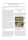
In general, the work carried out on vegetation in the
Mediterranean catchments is focused more on the hillside
vegetation cover than the riparian. Apart from occasional
contributions by Alcaraz et al. (1997), Salinas et al. (2000),
Mant (2002), Corbacho et al., (2003), Hooke et al. (2005),
little more has been published about the vegetation of
ephemeral channels in the Southeast of Spain. Specifi ...
[++]
Materias
Checkdams,
Ephemeral gullies
Editor
Universidad Pública de Navarra / Nafarroako Unibertsitate Publikoa
Publicado en
Javier Casalí, Rafael Giménez (eds.): Progress in Gully Erosion Research. IV International Symposium on Gully Erosion. September 17-19, 2007. Pamplona, Spain. Pamplona: Universidad Pública de Navarra / Nafarroako Unibertsitate Publikoa, 2007
Notas
Resumen del trabajo presentado al IV International Symposium on Gully Erosion, celebrado en la Universidad Pública de Navarra del 17 al 19 de septiembre de 2007.
Entidades Financiadoras
Part of the work reported in this paper was financially
supported by the Fundación Instituto Euromediterráneo de Hidrotecnia,
European Council, and Comunidad Autónoma de la Región de Murcia, Spain.
