Mostrar el registro sencillo del ítem
Relation between the location of check dams and adjacent vegetation cover in ephemeral gullies (Southeast Spain)
| dc.creator | Conesa García, C. | es_ES |
| dc.creator | Pérez Cutillas, P. | es_ES |
| dc.creator | García Lorenzo, R. | es_ES |
| dc.date.accessioned | 2018-02-20T07:39:38Z | |
| dc.date.available | 2018-02-20T07:39:38Z | |
| dc.date.issued | 2007 | |
| dc.identifier.isbn | 978-84–9769-198-7 | |
| dc.identifier.uri | https://hdl.handle.net/2454/27373 | |
| dc.description | Resumen del trabajo presentado al IV International Symposium on Gully Erosion, celebrado en la Universidad Pública de Navarra del 17 al 19 de septiembre de 2007. | es_ES |
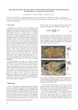
| dc.description.abstract | In general, the work carried out on vegetation in the Mediterranean catchments is focused more on the hillside vegetation cover than the riparian. Apart from occasional contributions by Alcaraz et al. (1997), Salinas et al. (2000), Mant (2002), Corbacho et al., (2003), Hooke et al. (2005), little more has been published about the vegetation of ephemeral channels in the Southeast of Spain. Specifically, the gullies create a very dynamic fluvial environment of which its connection with the morphological and hydraulic effects of riparian vegetation has been little studied up until now. The channel stability within these torrential streams depends a great deal on how much it is subject to erosion, as well as the production of sediments from the areas directly related to them (upper channel reaches and adjacent hillslopes). This is of unquestionable interest in channels being corrected by check dams, especially to assess the adequacy of their location (Conesa-García et al., 2007). The current paper adds a straightforward methodology in such a way, which relates the location of check dams to the level of vegetation cover developing in the plots of land surrounding the thalweg. For the purpose of study, two semiarid gullied catchments have been chosen, which have a strong tendency to dry up: the Torrecilla and Cárcavo catchments (Southeast Spain). The catchment of Torrecilla (15.5 km2) shows a “gullied” landscape developed on metamorphic materials (slates, phyllites, schists and quartzites), while the Cárvaco catchment (34.8 km2) is drained by ephemeral channels and gullies that deeply dissect the Miocene marls and Quaternary pediments. The projects of hydrological rectification undertaken are similar in both catchments: 33 and 40 check dam series were respectively built during the 1970´s, most of them with gabions. | en |
| dc.description.sponsorship | Part of the work reported in this paper was financially supported by the Fundación Instituto Euromediterráneo de Hidrotecnia, European Council, and Comunidad Autónoma de la Región de Murcia, Spain. | en |
| dc.format.extent | 2 p. | |
| dc.format.mimetype | application/pdf | en |
| dc.language.iso | eng | en |
| dc.publisher | Universidad Pública de Navarra / Nafarroako Unibertsitate Publikoa | es |
| dc.relation.ispartof | Javier Casalí, Rafael Giménez (eds.): Progress in Gully Erosion Research. IV International Symposium on Gully Erosion. September 17-19, 2007. Pamplona, Spain. Pamplona: Universidad Pública de Navarra / Nafarroako Unibertsitate Publikoa, 2007 | es |
| dc.rights | © Autores; Universidad Pública de Navarra. Esta publicación no puede ser reproducida, almacenada o transmitida total o parcialmente, sea cual fuere el medio y el procedimiento, incluidas las fotocopias, sin permiso previo concedido por escrito por los titulares del copyright. | es_ES |
| dc.subject | Checkdams | en |
| dc.subject | Ephemeral gullies | en |
| dc.title | Relation between the location of check dams and adjacent vegetation cover in ephemeral gullies (Southeast Spain) | en |
| dc.type | info:eu-repo/semantics/conferenceObject | en |
| dc.type | Contribución a congreso / Biltzarrerako ekarpena | es |
| dc.rights.accessRights | info:eu-repo/semantics/openAccess | en |
| dc.rights.accessRights | Acceso abierto / Sarbide irekia | es |
| dc.type.version | info:eu-repo/semantics/publishedVersion | en |
| dc.type.version | Versión publicada / Argitaratu den bertsioa | es |